• Skip to main content
  • Skip to primary sidebar

Texas A&M Center for Applied Technology

Innovation. Delivered.

Texas A&M University College of Engineering
  • Home
  • About TCAT
  • Research
  • People
  • Contact Us

Research

Local & State of Texas

Brazos Valley Water Smart Portal

Screenshot of the Brazos Valley Watersmart website with a map of the county and icons indicating regions that do not need to water their lawns today.
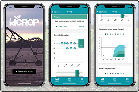
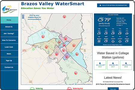
A web-based tool that provides lawn irrigation assistance based on real-time rainfall and weather conditions obtained directly from weather stations, along with educational materials related to residential water conservation.
Sponsor: City of College Station, Texas
  • Competencies: Data Fusion
  • Industries: Agriculture, Local & State of Texas

COVID Key

Image containing the COVID Key application logo, a smartphone displaying the COVID Key login screen, and a smartphone displaying the user's COVID clearance results.
A technology platform that combines data from vital signs screening, daily health surveys, SARS-CoV-2 infection testing results, and vaccination status, designed to support reporting of an individual’s current COVID-19 status through an iterative monitoring protocol performed over a defined time period.
Sponsor: Texas A&M Health
  • Competencies: Medical Technology, Mobile Data Collection
  • Industries: Medical, Data Analytics, Local & State of Texas

DIEM

Dashboard for Irrigation Efficiency Management

Screenshot of the Dashboard for Irrigation Efficiency Management (DIEM) web application displaying an input parameter component and numerous resulting graphs.
An integrated, web-based software solution for forecasting field-specific irrigation schedules that optimize rainfall and irrigation productivity. This is accomplished by configuring basic historic, near real-time, and future agronomic information including weather, soil and crop characteristics, and irrigation parameters into a variety of interactive data visualizations for portraying key aspects that support irrigation decisions.
Sponsor: State of Texas
  • Competencies: Modeling & Simulation, Data Fusion, Decision Support
  • Industries: Agriculture, Local & State of Texas

DREAMSTM Digital EMS

Disaster Relief & Emergency Medical Services

This image depicts 4 aspects of the DREAMS (Disaster Relief and Emergency Medical Services) Digital EMS project: a screenshot of the software user interface, a military HMMWV ambulance, a white civilian ambulance, and a dual-screen Physician cart.
A mobile telemedicine solution providing high quality video, audio and patient physiologic data in real-time from mobile remote ambulances, deployable systems, and portable kits to hospital physicians to enable earlier physician intervention, resulting in increased survivability and reduced morbidity.
Sponsor: U.S. Army Medical Research and Development Command
  • Competencies: Medical Technology, Decision Support
  • Industries: Medical, Emergency Response, Training, Federal Agencies, Local & State of Texas

EM*ES Virtual

Emergency Management Exercise System – Virtual

Screenshot of the first-person Emergency Management Exercise System – Virtual (EM*ES Virtual) simulation-based virtual training system. The screen displays multiple fire personnel carrying a stretcher to retrieve an injured industry worker.
A simulation-based, virtual training system to support TEEX’s Industrial Incident Management and Incident Command training program. This system immerses trainees into highly realistic situations, provides opportunities to exercise management and response doctrine within situation-specific emergencies, and enables for a richer and more effective training experience for participants.
Sponsor: Texas A&M Extension Service
  • Competencies: Modeling & Simulation, Decision Support
  • Industries: Emergency Response, Training, Federal Agencies, Local & State of Texas

EM*ES

Emergency Management Exercise System

Screenshot of the Emergency Management Exercise System (EM*ES) in which a timeclock is displayed in the upper left corner, a tabbed menu across the top, and the remainder of the screen is a 2D map overlayed with various boundary lines and a plume model.
An exercise management system used to help train both civilian and military emergency response personnel in large-scale incident management and planning. Over 25,000 U.S. and international emergency responders have been trained in exercises ranging from the incident command post up to the state operations level.
Sponsor: Texas A&M Extension Service
  • Competencies: Modeling & Simulation, Decision Support
  • Industries: Emergency Response, Training, Federal Agencies, Local & State of Texas

EPS

Enhanced Passive Surveillance Analyst Workstation

Screenshot of the AgConnect Enhanced Passive Surveillance (EPS) web application that consists of a 2D map of the south-western U.S. and various counties colored within Arizona and New Mexico. The map is surrounded by numerous dashboard components providing various modeling data and information. Overlayed on the image is an iPad showing a screenshot of the mobile app with Texas counties color-coded and a graph of data.
A system for integrating and analyzing syndromic surveillance data captured from mobile apps and other relevant sources. The data is aggregated and combined with embedded visualization and analysis tools to help determine baseline conditions in order to detect any anomalies that may signal the onset of an animal disease outbreak. This is one perspective of the AgConnect system.
Sponsor: U.S. Department of Homeland Security – Science and Technology Directorate
  • Competencies: Data Fusion, Data Visualization, Modeling & Simulation, Decision Support
  • Industries: Emergency Response, Federal Agencies, Local & State of Texas

FAST-STAR

Fletcher Allen Specialized Telemedicine for Supporting Transfer And Rescue

This image depicts several aspects of the FASTSTAR (Fletcher Allen Specialized Telemedicine for Supporting Transfer And Rescue) digital ambulance project: a rugged mobile laptop with a FASTSTAR screenshot, a rugged Grab & Go case with external connectors for various devices, and a photo of the FASTSTAR ambulance.
Designed, developed, deployed, and supported a fleet of five digital ambulances for the Fletcher Allen Level 1 trauma center in Burlington, Vermont. Also fielded a standalone deployable wireless on-scene camera as well as portable “Grab & Go” cases to be used with ambulances outfitted with minimal pre-install equipment.
Sponsor: U.S. Department of Transportation
  • Competencies: Medical Technology, Decision Support
  • Industries: Medical, Emergency Response, Training, Federal Agencies, Local & State of Texas

idCROP

Irrigation Decision Support System for Conserving Resources and Optimizing Production

Image of three smartphones displaying login and two results screenshots from the Irrigation Decision Support System for Conserving Resources and Optimizing Production (idCROP) mobile application.
A producer-friendly crop model- and sensor-based irrigation decision support system designed to provide real-time irrigation schedules and projected economic outcomes based on water use and production goals. The system uses management information from the user in conjunction with externally sourced data, including projected short-term weather, and generates crop growth and economic model scenarios. Remote detection of plant water stress using a sensor platform mounted on a pivot irrigation system improves irrigation schedules. Demonstrated with cotton in the Texas Rolling Plains region.
Sponsor: State of Texas
  • Competencies: Modeling & Simulation, Data Fusion, Decision Support
  • Industries: Agriculture, Local & State of Texas

Lifeline

Screenshots of Lifeline dispatcher web application consisting of a a 2D aerial map on the right overlayed with a selected dispatch location and a list of events/personnel on the left. Overlayed on top of the screenshot is a smartphone with the Lifeline app login screen.
An integrated system that enables exploration of innovative healthcare delivery models, linking those in immediate need of emergency medical services with those qualified individuals that are nearby and capable of responding.
Sponsor: Texas A&M Health
  • Competencies: Medical Technology, Geospatial Computing, Mobile Data Collection
  • Industries: Emergency Response, Local & State of Texas

  • 1
  • Go to page 2
  • Go to Next Page »

Navigation

  • About TCAT
    • Brief History
    • Our Model & Approach
  • Research
    • Competencies
    • Industries
  • People
  • Contact Us

Competencies

Configuration Management
Data Analytics
Data Fusion
Data Visualization
Decision Support
Digital Transformation
Digital Twins
Facility Management
Geospatial Computing
Interactive Media
Medical Technology
Mobile Data Collection
Modeling & Simulation

Industries

Agriculture
Data Analytics
Decision Support
Emergency Response
Facility Management
Federal Agencies
Local & State of Texas
Medical
National Security
Non-Profits
Private Industry
Texas A&M University System
Training

© 2016–2025 Texas A&M Center for Applied Technology Log in

Texas A&M Engineering Experiment Station Logo
  • College of Engineering
  • Facebook
  • Twitter
  • State of Texas
  • Open Records
  • Risk, Fraud & Misconduct Hotline
  • Statewide Search
  • Site Links & Policies
  • Accommodations
  • Environmental Health, Safety & Security
  • Employment