• Skip to main content
  • Skip to primary sidebar

Texas A&M Center for Applied Technology

Innovation. Delivered.

Texas A&M University College of Engineering
  • Home
  • About TCAT
  • Research
  • People
  • Contact Us

Research

Modeling & Simulation

idCROP

Irrigation Decision Support System for Conserving Resources and Optimizing Production

Image of three smartphones displaying login and two results screenshots from the Irrigation Decision Support System for Conserving Resources and Optimizing Production (idCROP) mobile application.
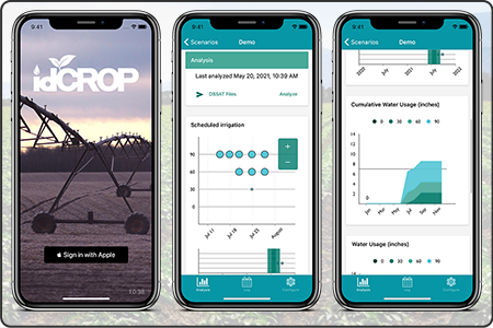
A producer-friendly crop model- and sensor-based irrigation decision support system designed to provide real-time irrigation schedules and projected economic outcomes based on water use and production goals. The system uses management information from the user in conjunction with externally sourced data, including projected short-term weather, and generates crop growth and economic model scenarios. Remote detection of plant water stress using a sensor platform mounted on a pivot irrigation system improves irrigation schedules. Demonstrated with cotton in the Texas Rolling Plains region.
Sponsor: State of Texas
  • Competencies: Modeling & Simulation, Data Fusion, Decision Support
  • Industries: Agriculture, Local & State of Texas

IES

Infrastructure and Essential Services

Screenshot of the Infrastructure and Essential Services (IES) splash screen.
Developed an infrastructure and essential services (IES) module that tracks and manages critical services such as water, electrical and agriculture modeling for a specific areas of operation within simulation federations.
Sponsor: U.S. Army TRADOC Analysis Center
  • Competencies: Modeling & Simulation, Decision Support
  • Industries: National Security, Federal Agencies

INFORMS

International Framework for Outbreak Response Modeling and Simulation

Screenshot of the International Framework for Outbreak Response Modeling and Simulation (INFORMS) web application displaying scenarios across the top and scenario result graphs along the bottom.
A simulation-based environment for modeling the spread of a disease within livestock or poultry, effectiveness of potential disease response and control strategies, and the associated monetary costs. The system enables parameterization, management, distributed execution and aggregation of results, supporting “what-if” analysis and comparison of strategies by epidemiologists and responders in order to understand and assess potential disease events and their associated impacts.
Sponsor: U.S. Department of Agriculture
  • Competencies: Modeling & Simulation, Data Visualization
  • Industries: Emergency Response, Federal Agencies

L1SEF

Level 1 Site Exploitation/Forensics

This is a project placeholder image of the TCAT challenge coin that consists of a picture of the state of Texas in red, white, and blue overlayed with the words "TCAT - Innovation. Delivered." The challenge coin is on top of a TCAT poster image from it's 20th anniversary back in 2014.
Developed a concept model to simulate Level 1 site exploitation of component debris following a detonation event by conventional or improvised explosives.
Sponsor: U.S. Army TRADOC Intelligence Support Activity
  • Competencies: Modeling & Simulation, Decision Support
  • Industries: National Security, Federal Agencies

Micro Grid

Deployable emergency power solution

Photo of the Micro Grid trailer, a deployable emergency power solution for emergency response and recovery operations along the Texas-Mexico border.
Developed and deployed an innovative and unique hybrid micro-grid technology that actively stores energy from renewable energy sources for as a deployable power solution for emergency response and recovery operations along the Texas-Mexico border.
Sponsor: U.S. Department of Energy, Texas State Energy Conservation Office, Texas Commission on Environmental Quality
  • Competencies: Data Analytics, Modeling & Simulation
  • Industries: Emergency Response, Federal Agencies, National Security

Phylogenetic Analysis Analyst Workstation

Screenshot of the AgConnect phylogenetics dashboard consisting of a 2D map overlayed with various icon markers. The map is surrounded by numerous dashboard components, including a circular dendogram displaying gene diversity.
A system to investigate strain movement and divergence across both time and space, as well as track and compare disease history and spread across animal production systems. The system integrates sequence data from multiple sources, incorporates different sequence alignment, comparison, and tree construction tools, and provides various visualization and analysis tools for working with the data. This is one perspective of the AgConnect system.
Sponsor: U.S. Department of Homeland Security – Science and Technology Directorate
  • Competencies: Data Fusion, Data Visualization, Modeling & Simulation, Decision Support
  • Industries: Agriculture, Federal Agencies

Poultry Depopulation Decision Support Tool

A photo inside a chicken production barn overlayed with a laptop displaying the data entry screen for the poultry depopulation decision support tool.
A decision support tool for assessing supplemental heat requirements in barn depopulation during a Highly Pathogenic Avian Influenza (HPAI) outbreak.
Sponsor: U.S. Poultry & Egg Association (USPOULTRY)
  • Competencies: Modeling & Simulation, Decision Support
  • Industries: Agriculture, Private Industry

WDSM

Wildlife Disease Spread Model

Screenshot of the Wildlife Disease Spread Model (WDSM) web application containing a 2D topographic map overlayed with colored boundaries. Surrounding the map are several information and data graph components.
Designed and developed a wildlife disease model for Classical Swine Fever (CSF) within feral swine to address limitations of current models, support assessment of the wildlife risk, inform strategies to prevent wildlife interaction, and simulate disease spread, potential time to detection, possible control and mitigation strategies, and the respective economic costs.
Sponsor: U.S. Department of Agriculture – Animal and Plant Health Inspection Service
  • Competencies: Modeling & Simulation, Data Visualization, Decision Support
  • Industries: Agriculture, Emergency Response, Training, Federal Agencies, Local & State of Texas

  • « Go to Previous Page
  • Go to page 1
  • 2

Navigation

  • About TCAT
    • Brief History
    • Our Model & Approach
  • Research
    • Competencies
    • Industries
  • People
  • Contact Us

Competencies

Configuration Management
Data Analytics
Data Fusion
Data Visualization
Decision Support
Digital Transformation
Digital Twins
Facility Management
Geospatial Computing
Interactive Media
Medical Technology
Mobile Data Collection
Modeling & Simulation

Industries

Agriculture
Data Analytics
Decision Support
Emergency Response
Facility Management
Federal Agencies
Local & State of Texas
Medical
National Security
Non-Profits
Private Industry
Texas A&M University System
Training

© 2016–2025 Texas A&M Center for Applied Technology Log in

Texas A&M Engineering Experiment Station Logo
  • College of Engineering
  • Facebook
  • Twitter
  • State of Texas
  • Open Records
  • Risk, Fraud & Misconduct Hotline
  • Statewide Search
  • Site Links & Policies
  • Accommodations
  • Environmental Health, Safety & Security
  • Employment