• Skip to main content
  • Skip to primary sidebar

Texas A&M Center for Applied Technology

Innovation. Delivered.

Texas A&M University College of Engineering
  • Home
  • About TCAT
  • Research
  • People
  • Contact Us

Research

Decision Support

3DTV

3D Terrain Visualization

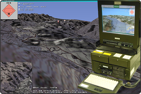
This image contains a screenshot of the 3D Terrain Visualization (3DTV) application in which there is a first-person view of rolling hills textured with military raster imagery, clickable icons of units in the field, a overhead scrolling map inset marking the user's position and orientation, and a text area indicating the user's latitude and longitude. Also pictured is the hardened and ruggedized military system running the 3DTV application.
Developed a 3D terrain visualization capability integrated by Lockheed Martin into the digital Army Battle Command System (ABCS) that provides accurate line of sight and real-time unit locations on an optimally adapting mesh terrain overlayed with military terrain imagery and unit symbology.
Sponsor: U.S. Army Central Technical Support Facility
  • Competencies: Modeling & Simulation, Data Visualization, Decision Support
  • Industries: National Security, Federal Agencies

ALIM

Asset Lifecyle Information Management System

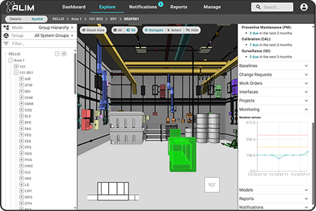
Screenshot of the Asset Lifecycle Information Management System (ALIM) web application user interface containing a hierarchy of functional locations on the left, a 3D rendering of a research bay with a selected X-Ray system in the center, and various properties of the X-Ray system on the right.
An integrative, data-driven framework to enhance situational awareness and decision support for day-to-day facility management, helping increase facility and equipment availability for production work through the strategic integration of data and technology.
Sponsor: U.S. Department of Energy
  • Competencies: Digital Twins, Data Visualization, Digital Transformation, Configuration Management, Facility Management, Decision Support
  • Industries: Federal Agencies

Athena

Human Social Cultural Behavior (HSCB) Decision Simulator

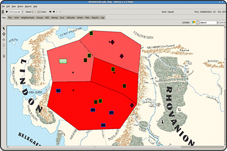
Screenshot of the Athena Human Social Cultural Behavior (HSCB) decision simulation application in which a 2D thematic map is overlayed with colored regions and unit icons.
Executed political, military, economic, social, infrastructure, information, physical environment, and time-based (PMESII+2) scenarios to anticipate trends over 1-3 month turns within 1-3 year periods to provide comprehensive analysis of coercion tipping points, insurgent growth rate, relationally based information exchange from competing non-combatant groups, and irregular battle command/PSYOP.
Sponsor: U.S. Army TRADOC Intelligence Support Activity
  • Competencies: Modeling & Simulation, Decision Support
  • Industries: National Security, Federal Agencies
COIN

Counter-Insurgency

This is a project placeholder image of the TCAT challenge coin that consists of a picture of the state of Texas in red, white, and blue overlayed with the words "TCAT - Innovation. Delivered." The challenge coin is on top of a TCAT poster image from it's 20th anniversary back in 2014.
Designed, executed, and analyzed scenarios within a Human Social Cultural Behavior (HSCB) simulation developed by NASA Jet Propulsion Laboratory (JPL) to assess irregular warfare effects and operations to influence violent extremist organizations.
Sponsor: U.S. Army TRADOC Intelligence Support Activity
  • Competencies: Modeling & Simulation, Decision Support
  • Industries: National Security, Federal Agencies
DIEM

Dashboard for Irrigation Efficiency Management

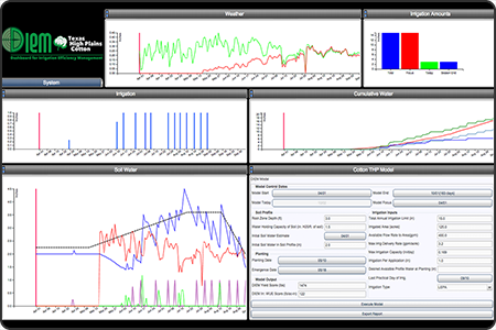
Screenshot of the Dashboard for Irrigation Efficiency Management (DIEM) web application displaying an input parameter component and numerous resulting graphs.
An integrated, web-based software solution for forecasting field-specific irrigation schedules that optimize rainfall and irrigation productivity. This is accomplished by configuring basic historic, near real-time, and future agronomic information including weather, soil and crop characteristics, and irrigation parameters into a variety of interactive data visualizations for portraying key aspects that support irrigation decisions.
Sponsor: State of Texas
  • Competencies: Modeling & Simulation, Data Fusion, Decision Support
  • Industries: Agriculture, Local & State of Texas

DREAMSTM Digital EMS

Disaster Relief & Emergency Medical Services

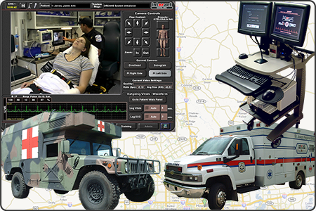
This image depicts 4 aspects of the DREAMS (Disaster Relief and Emergency Medical Services) Digital EMS project: a screenshot of the software user interface, a military HMMWV ambulance, a white civilian ambulance, and a dual-screen Physician cart.
A mobile telemedicine solution providing high quality video, audio and patient physiologic data in real-time from mobile remote ambulances, deployable systems, and portable kits to hospital physicians to enable earlier physician intervention, resulting in increased survivability and reduced morbidity.
Sponsor: U.S. Army Medical Research and Development Command
  • Competencies: Medical Technology, Decision Support
  • Industries: Medical, Emergency Response, Training, Federal Agencies, Local & State of Texas

ELITE

Electronic Laboratory Information Tracking Environment

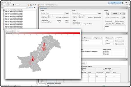
Screenshot of the Electronic Laboratory Information Tracking Environment (ELITE) application overlayed by a colored heatmap displaying quantity of disease incidents by region.
A technology that pairs a Laboratory Information Management System (LIMS) supporting daily laboratory operations with a biosurveillance module for monitoring, reporting and analyzing tracked test results for program diseases such as foot-and-mouth disease (FMD). The system can be configured to support numerous custom test types, test procedures, laboratory workflows, forms and reports, and hardware/network infrastructure, and can be defined locally or distributed throughout a network of laboratories.
Sponsor: U.S. Department of Agriculture – Foreign Agriculture Services
  • Competencies: Data Fusion, Data Visualization, Decision Support
  • Industries: Agriculture, Federal Agencies

EM*ES Virtual

Emergency Management Exercise System – Virtual

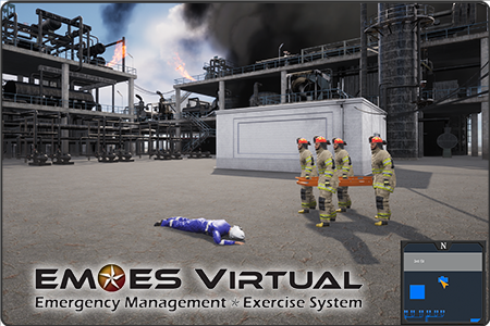
Screenshot of the first-person Emergency Management Exercise System – Virtual (EM*ES Virtual) simulation-based virtual training system. The screen displays multiple fire personnel carrying a stretcher to retrieve an injured industry worker.
A simulation-based, virtual training system to support TEEX’s Industrial Incident Management and Incident Command training program. This system immerses trainees into highly realistic situations, provides opportunities to exercise management and response doctrine within situation-specific emergencies, and enables for a richer and more effective training experience for participants.
Sponsor: Texas A&M Extension Service
  • Competencies: Modeling & Simulation, Decision Support
  • Industries: Emergency Response, Training, Federal Agencies, Local & State of Texas

EM*ES

Emergency Management Exercise System

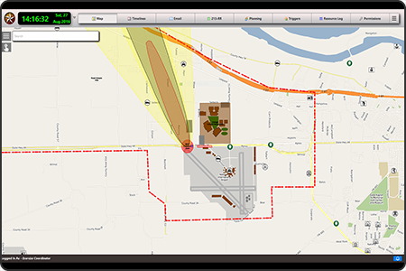
Screenshot of the Emergency Management Exercise System (EM*ES) in which a timeclock is displayed in the upper left corner, a tabbed menu across the top, and the remainder of the screen is a 2D map overlayed with various boundary lines and a plume model.
An exercise management system used to help train both civilian and military emergency response personnel in large-scale incident management and planning. Over 25,000 U.S. and international emergency responders have been trained in exercises ranging from the incident command post up to the state operations level.
Sponsor: Texas A&M Extension Service
  • Competencies: Modeling & Simulation, Decision Support
  • Industries: Emergency Response, Training, Federal Agencies, Local & State of Texas

EMBM

Electromagnetic Battle Management

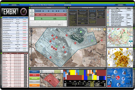
Screenshot of the Electromagnetic Battle Management (EMBM) proof-fo-concept dashboard displaying a 2D aerial map in the center overlayed with filled boundaries and icons. The map is surrounded by numerous by numerous dashboard components providing various modeling data and information.
A proof-of-concept dashboard with customizable user-defined profiles, interchangeable components and enhanced visualization and analytical capabilities designed to assist Joint-level electromagnetic battle managers in the preparation, planning, execution, and analysis of warfighter operations.
Sponsor: U.S. Department of Defense
  • Competencies: Data Fusion, Data Visualization, Decision Support
  • Industries: Federal Agencies

  • 1
  • Go to page 2
  • Go to page 3
  • Go to Next Page »

Navigation

  • About TCAT
    • Brief History
    • Our Model & Approach
  • Research
    • Competencies
    • Industries
  • People
  • Contact Us

Competencies

Configuration Management
Data Analytics
Data Fusion
Data Visualization
Decision Support
Digital Transformation
Digital Twins
Facility Management
Geospatial Computing
Interactive Media
Medical Technology
Mobile Data Collection
Modeling & Simulation

Industries

Agriculture
Data Analytics
Decision Support
Emergency Response
Facility Management
Federal Agencies
Local & State of Texas
Medical
National Security
Non-Profits
Private Industry
Texas A&M University System
Training

© 2016–2025 Texas A&M Center for Applied Technology Log in

Texas A&M Engineering Experiment Station Logo
  • College of Engineering
  • Facebook
  • Twitter
  • State of Texas
  • Open Records
  • Risk, Fraud & Misconduct Hotline
  • Statewide Search
  • Site Links & Policies
  • Accommodations
  • Environmental Health, Safety & Security
  • Employment